

Scientists cable seafloor seismometer into state earthquake network
| 18 March 2009
BERKELEY — A newly laid, 32-mile underwater cable finally links the state's only seafloor seismic station with the University of California, Berkeley's seismic network, merging real-time data from west of the San Andreas fault with data from 31 other land stations sprinkled around Northern and Central California.
"Before, we had to wait three months to even know if the instruments were alive," said Barbara Romanowicz, director of the Berkeley Seismological Laboratory and a UC Berkeley professor of earth and planetary science. Now, she said, "we can use the data from the seafloor station in real time together with those from the rest of the Berkeley Digital Seismic Network" to determine the location, magnitude and mechanism of offshore earthquakes, learn about the crust at the edge of the continental plate and understand better the hazards of the San Andreas fault system that runs north and south through the state.
According to Romanowicz, earthquake monitoring systems around the world have been trying to place seismometers on the seafloor for decades to cover the 71 percent of the Earth's surface that is beneath the oceans. Islands have generally provided the only offshore data - the Berkeley network has one seismic station on the Farallon Islands - but these provide only spotty coverage.
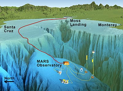 The MARS cable connects a seafloor science node (orange) to the shore at Moss Landing, just north of Monterey. Many scientific instruments can be plugged into the node, though at the moment only the broadband seismometer (blue and white cylinder) and the fish sonar (not shown) are sending back real-time data to researchers on-shore. (Courtesy of MBARI)
"Even though we correct for this lopsidedness, the calculations would be even more reliable if we could include data from more stations west of the fault; with the addition of MOBB, we achieve this goal," wrote Berkeley Seismological Laboratory research geophysicist Peggy Hellweg on the lab's SeismoBlog, http://seismo.berkeley.edu/blogs/seismoblog.php.
Also, while basic, disposable seismometers can be thrown overboard to collect data for short periods of time, more expensive broadband seismometers, which can detect a wide range of vibrational frequencies and a large amplitude range, are preferred. The latter are necessary to gather the data needed for modeling earthquakes and eventually providing a few tens of seconds' warning of impending ground shaking.
Romanowicz teamed up with the institute more than 12 years ago to develop a seafloor seismic observatory. For three months in 1997, in collaboration with the Berkeley Seismological Laboratory and a team from France, MBARI placed a broadband seismometer on the floor of Monterey Bay to test the equipment and installation procedures. The Monterey Ocean Bottom Broadband (MOBB) station was permanently situated on an underwater ridge in April 2002 (http://berkeley.edu/news/media/releases/2002/04/12_auake.html).
With MOBB data coming back to UC Berkeley only once every three months, it could not be used in real-time earthquake monitoring. It has proved valuable in other studies, however, including an investigation of long-period ocean waves, called infragravity waves, that are thought to generate a low-frequency hum in Earth.
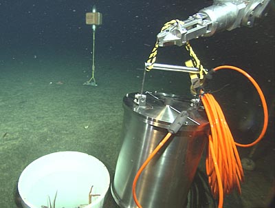 The broadband seismometer encased in a titanium canister just before being lowered into a hole excavated in the ocean bottom. The current meter attached to the Monterey Ocean Bottom Broadband station is in the background, while the arm of the remotely operated vehicle Ventana holds the canister. (Courtesy MBARI 2002)
"How the interactions of waves couple to the ground is still an open question," said Romanowicz. "MOBB will allow us to compare seismic data with data from buoys to determine the temporal and spatial relationships between ocean waves, infragravity waves and seismic waves."
Earth's hum as well as ocean currents and breaking surf all make the seismic data from MOBB noisier than data from land stations, Romanowicz said, which means MOBB data must be processed to remove the noise before it can be integrated with other seismic data in the network. She and UC Berkeley colleagues are working on real-time algorithms that can do such processing quickly. The data from the ocean floor seismometer will soon be available, along with other broadband seismic data from land-based stations, at the Northern California Earthquake Data Center: http://www.ncedc.org/), an archive of earthquake date maintained by UC Berkeley and the U.S. Geological Survey.
If MOBB turns out to provide useful data for the Northern California seismic network, it will be a prototype for other seafloor seismic stations she hopes to emplace along the coast from below Monterey to Point Reyes.
Romanowicz is first author of a paper describing real-time data acquisition from MOBB in the March/April edition of Seismological Research Letters.
Also recently connected to MARS, which is supported by the National Science Foundation, is a University of Washington underwater acoustic package designed to monitor movements of fish and zooplankton. To read more about MBARI's plans to connect more experiments to the science node, see http://www.mbari.org/news/homepage/2009/mars-mobb-deimos.html
For more information:
-- About MARS, see http://www.mbari.org/mars/
-- About
the Berkeley Seismological Laboratory, see http://seismo.berkeley.edu/